Ik heb een probleem met iSailor waar ik mijn vinger niet op krijg: tijdens het varen met iSailor als aansturing voor mijn stuurautomaat springt hij er geregeld af met de melding dat ik te ver buiten mijn track ben. Om een en ander uit te sluiten heb ik een track opgeslagen op iSailor en zie daar inderdaad verspringingen die ik niet kan verklaren. Volgens de track ben ik geregeld in Duitsland te vinden (wat ik toch zeer zeker niet ben
Wat opvalt is dat elke keer als ik een verspringing naar Duitsland heb, dat ik deze ook als aparte <trkseg> node is opgenomen.
Ik gebruik als input de GPS locatie die door de AIS in het AIVDO bericht wordt gezet. Na even een eenvoudig parsertje geschreven te hebben blijkt dat de roosmux niets op de bus zet wat met een oost-coördinaat in de 9" zit.
[25-9-2020 07:38:16] !AIVDO,1,1,,,B3`nuGP0@85?p@WIG98h3wW5oP06,0*25 *** DecodeStandardClassBPositionReport *** MMSI: 244170078; SOG: 6,4; COG: 76,8; Lat: 51" 42,22260000000006' ; Long: 4" 35,152099999999976'
[25-9-2020 07:38:17] !AIVDO,1,1,,,B3`nuGP0@`5?pOWIG9HgkwWUoP06,0*35 *** DecodeStandardClassBPositionReport *** MMSI: 244170078; SOG: 6,6; COG: 76,4; Lat: 51" 42,2229999999999' ; Long: 4" 35,155100000000026'
[25-9-2020 07:38:17] !AIVDO,1,1,,,B3`nuGP0@H5?pe7IG9`gsw`5oP06,0*30 *** DecodeStandardClassBPositionReport *** MMSI: 244170078; SOG: 6,5; COG: 76,6; Lat: 51" 42,22340000000017' ; Long: 4" 35,15779999999998'
[25-9-2020 07:38:20] !AIVDO,1,1,,,B3`nuGP0@H5?ps7IG9tgOw`UoP06,0*6E *** DecodeStandardClassBPositionReport *** MMSI: 244170078; SOG: 6,5; COG: 75,9; Lat: 51" 42,223900000000185' ; Long: 4" 35,160599999999995'
[25-9-2020 07:38:21] !AIVDO,1,1,,,B3`nuGP0@H5?q97IG:<gGwa5oP06,0*07 *** DecodeStandardClassBPositionReport *** MMSI: 244170078; SOG: 6,5; COG: 75,7; Lat: 51" 42,22430000000003' ; Long: 4" 35,16340000000001'
[25-9-2020 07:38:21] !AIVDO,1,1,,,B3`nuGP0?p5?qG7IG:Pg?waUoP06,0*4A *** DecodeStandardClassBPositionReport *** MMSI: 244170078; SOG: 6,3; COG: 75,5; Lat: 51" 42,224800000000045' ; Long: 4" 35,166199999999975'
[25-9-2020 07:38:21] !AIVDO,1,1,,,B3`nuGP0@H5?qV7IG:lgcwb5oP06,0*1F *** DecodeStandardClassBPositionReport *** MMSI: 244170078; SOG: 6,5; COG: 76,2; Lat: 51" 42,22530000000006' ; Long: 4" 35,169200000000025'
[25-9-2020 07:38:24] !AIVDO,1,1,,,B3`nuGP0?`5?qkWIG;4gGwbUoP06,0*08 *** DecodeStandardClassBPositionReport *** MMSI: 244170078; SOG: 6,2; COG: 75,7; Lat: 51" 42,225699999999904' ; Long: 4" 35,17189999999998'
[25-9-2020 07:38:25] !AIVDO,1,1,,,B3`nuGP0@85?r07IG;DgKwc5oP06,0*0A *** DecodeStandardClassBPositionReport *** MMSI: 244170078; SOG: 6,4; COG: 75,8; Lat: 51" 42,22610000000017' ; Long: 4" 35,174400000000006'
[25-9-2020 07:38:26] !AIVDO,1,1,,,B3`nuGP0@85?r=WIG;TgCwcUoP06,0*1F *** DecodeStandardClassBPositionReport *** MMSI: 244170078; SOG: 6,4; COG: 75,6; Lat: 51" 42,226500000000016' ; Long: 4" 35,17710000000001'
[25-9-2020 07:38:27] !AIVDO,1,1,,,B3`nuGP0@H5?rKWIG;pgKwd5oP06,0*52 *** DecodeStandardClassBPositionReport *** MMSI: 244170078; SOG: 6,5; COG: 75,8; Lat: 51" 42,22700000000003' ; Long: 4" 35,179899999999975'
[25-9-2020 07:38:28] !AIVDO,1,1,,,B3`nuGP0@H5?rb7IG<<gOwdUoP06,0*34 *** DecodeStandardClassBPositionReport *** MMSI: 244170078; SOG: 6,5; COG: 75,9; Lat: 51" 42,22750000000005' ; Long: 4" 35,18280000000001'
[25-9-2020 07:38:29] !AIVDO,1,1,,,B3`nuGP0@H5?rp7IG<LgKwe5oP06,0*33 *** DecodeStandardClassBPositionReport *** MMSI: 244170078; SOG: 6,5; COG: 75,8; Lat: 51" 42,22789999999989' ; Long: 4" 35,18560000000002'
[25-9-2020 07:38:30] !AIVDO,1,1,,,B3`nuGP0@H5?s67IG<lgGweUoP06,0*38 *** DecodeStandardClassBPositionReport *** MMSI: 244170078; SOG: 6,5; COG: 75,7; Lat: 51" 42,22850000000008' ; Long: 4" 35,18839999999999'
[25-9-2020 07:38:31] !AIVDO,1,1,,,B3`nuGP0@85?sD7IG=8fwwf5oP06,0*3D *** DecodeStandardClassBPositionReport *** MMSI: 244170078; SOG: 6,4; COG: 75,1; Lat: 51" 42,2290000000001' ; Long: 4" 35,19120000000001'
[25-9-2020 07:38:32] !AIVDO,1,1,,,B3`nuGP0@H5?sR7IG=HgCwfUoP06,0*7E *** DecodeStandardClassBPositionReport *** MMSI: 244170078; SOG: 6,5; COG: 75,6; Lat: 51" 42,22939999999994' ; Long: 4" 35,193999999999974'
[25-9-2020 07:38:33] !AIVDO,1,1,,,B3`nuGP0@H5?sh7IG=dg;wg5oP06,0*71 *** DecodeStandardClassBPositionReport *** MMSI: 244170078; SOG: 6,5; COG: 75,4; Lat: 51" 42,22989999999996' ; Long: 4" 35,196799999999996'
[25-9-2020 07:38:34] !AIVDO,1,1,,,B3`nuGP0@H5?svWIG=tgGwgUoP06,0*03 *** DecodeStandardClassBPositionReport *** MMSI: 244170078; SOG: 6,5; COG: 75,7; Lat: 51" 42,2302999999998' ; Long: 4" 35,19970000000002'
[25-9-2020 07:38:35] !AIVDO,1,1,,,B3`nuGP0@85?t<WIG>@fwwh5oP06,0*57 *** DecodeStandardClassBPositionReport *** MMSI: 244170078; SOG: 6,4; COG: 75,1; Lat: 51" 42,23079999999982' ; Long: 4" 35,202499999999986'
[25-9-2020 07:38:36] !AIVDO,1,1,,,B3`nuGP0@85?tJWIG>Pg;whUoP06,0*1C *** DecodeStandardClassBPositionReport *** MMSI: 244170078; SOG: 6,4; COG: 75,4; Lat: 51" 42,23120000000009' ; Long: 4" 35,20530000000001'
[25-9-2020 07:38:36] !AIVDO,1,1,,,B3`nuGP0@85?ta7IG>lgGwi5oP06,0*76 *** DecodeStandardClassBPositionReport *** MMSI: 244170078; SOG: 6,4; COG: 75,7; Lat: 51" 42,2317000000001' ; Long: 4" 35,20819999999999'
[25-9-2020 07:38:38] !AIVDO,1,1,,,B3`nuGP0@85?to7IG?4g7wiUoP06,0*31 *** DecodeStandardClassBPositionReport *** MMSI: 244170078; SOG: 6,4; COG: 75,3; Lat: 51" 42,232099999999946' ; Long: 4" 35,211000000000006'
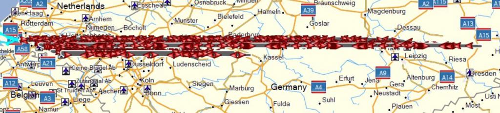
Voor een tochtje van Noordschans naar Eindhoven niet de meest efficiënte route. Ik ben er dan ook vrij zeker van dat we dit niet hebben gevaren
Wat opvalt is dat de Oost-coördinaat alleen fout gaat.
Heeft iemand ervaring met het gebruik van iSailor in combinatie met de aansturing van de navigatie of heeft iemand soortgelijke uitdagingen?